Last class revision (5:16 PM).
Earthquakes (continued) (5:28 PM):
- Causes of earthquake:
- Natural causes:
- Plate movements
- Volcanic eruption.
- Landsides.
- Land Subsidence.
- Meteoritic impact.
- Anthropogenic causes:
- Mining and blasting.
- Nuclear explosion.
- Reservoir-induced seismicity(RIS).
- The scientific study of earthquakes is called seismology.
Earthquake waves(5.35 PM):
- Diagrammatic representations of Earthquake waves:
- During an earthquake, the point where the energy is released below the surface is called the focus/hypocentre.
- The point on the surface nearest to the focus is called the epicentre.
- An earthquake generates two types of waves, body and surface waves.
- Body waves:
- These earthquake waves are generated at the focus and move through the earth's interior.
- There are two types of body waves, P-wave and S-wave.
- P-waves(Primary waves):
- These are the first to be detected during an earthquake.
- They are also called compressional waves and longitudinal waves.
- They oscillate back and forth in the direction of propagation.
- P-Waves depend on the density and rigidity of the material.
- P- waves can travel through solid, liquid, and gas.
- S-waves(secondary waves):
- S waves oscillate perpendicularly to the direction of propagation.
- They are also called transverse waves.
- The S-wave movement depends on the material's density and rigidity.
- Therefore S waves cannot pass through liquid and gas.
- Surface waves:
- These are the earthquake waves confined to the surface of the earth.
- They are generated due to the interaction of body waves with the surface and generally at the epicentre.
- Surface waves are much slower than body waves but cause more damage.
- Examples are Love waves and Raleigh waves.
Shadow zones(6.18 PM):
- Diagrammatic representation of shadow zones:

- The seismic waves undergo reflection, bending, or changes in direction while passing from one medium to another.
- This results in the creation of shadow zones.
- The Shadow zone is the zone in the earth's interior from where earthquake waves are not reported.
- P-wave shadow zone:
- P-waves are not detected between 105-145 degrees from the focus resulting in the P-wave shadow zone.
- It is due to a change in direction of P-waves as it enters the outer core.
- S-wave shadow zone:
- S-waves cannot pass through the liquid outer core.
- Therefore beyond 105 degrees, we observe S-wave shadow zones.
- By studying the different earthquake waves, the extent of their shadow zone, and other characteristics we can conclude about the earth's interior.
Type of earthquake (6:32 PM)
- Shallow focus earthquake occurs at the depth of 0-70 km.
- Intermediate focus earthquake occurs at the depth of 70-350 km.
- Deep-focus earthquake occurs at the depth of more than 350 km.
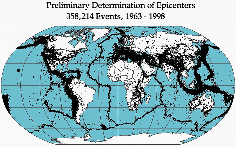
Distribution of earthquakes (6:35 PM):
- Circum-pacific belt:
- Around the pacific ocean.
- Along the west due to ocean-ocean convergence.
- Along the east due to ocean-continent convergence.
- Mid-oceanic ridges:
- Around the regions of ocean-ocean divergence
- Meditarian and trans-asiatic belt:
- Continent-continent convergence.
- East African rift valley:
- Continent-continent divergence.
- Diagramatic representation of the distribution of earthquakes:
Measurement of earthquakes (7:03 PM)
- The earthquake waves can be recorded by a seismograph.
- The record produced by the seismograph is called a seismogram.
- Magnitude and intensity of the earthquakes:
-
Magnitude: Intensity: It is the measure of the amount of energy released during an earthquake.
Intensity is the assessment of visible damage caused by an earthquake.
The magnitude remains constant for earthquakes.
Intensity decreases away from the epicentre.
It is an objective measure.
It is a subjective measure.
The magnitude is measured by the Richter scale.
There is no upper limit for the Richter scale.
Richter scale is a logarithm scale that is 1 unit change means a 10 times stronger earthquake.
Intensity is measured by a Modified Mercalli scale.
The range of the Mercalli scale is 1-12.
- The highest recorded earthquake is a 9.5 Richter scale in Chile in 1960.
- 2004 Indian ocean(Indonesia) earthquake was 9.1 magnitudes.
- 2011 japan earthquake was 9.1 magnitudes.
- Earthquake in India:
- 2001 Bhuj earthquake was 7.7 magnitudes.
- The 2005 earthquake in Kasmir was of 7.6 magnitudes.
- 2011 Sikkim-Nepal earthquake was of 6.9 magnitudes.
- The 1993 Latur earthquake was of 6.2 magnitudes.
- 1991 Uttarkashi earthquake was of 6.1 magnitudes.
T-sunami (7:31 PM)
- A tsunami is a Japanese word for harbour waves.
- They are also called seismic sea waves.
- They are four stages in the occurrence of a tsunami:
- Generation:
- Tsunamis are generated due to vertical displacement of the column of seawater which causes by:
- Earthquakes, normal and reverse fault earthquakes along the oceanic floor.
- Underwater Volcanic eruptions.
- Underwater landslide and subsidence.
- Meteorites impact.
- Underwater nuclear test.
- Propagation in deep water:
- Along deeper waters, the speed of waves is very high and the amplitude will is low.
- Therefore tsunamis will not be visible in the open ocean nor will cause any damage.
- Propagation in shallow water:
- As depth decreases, the amplitude increases, and the speed of waves decreases.
- This causes a pilling up of water near the coast, generating very high waves, this is called the shoaling effect.
- Landfall:
- Where the waves break and submerge the coastal regions.
The topic of the next class: Exogenetic movements.